This travel series isn't complete without some reflecting (I love to reflect!) and some statistics. I've been writing this for the last two weeks and it just keeps getting longer, so I need to stop and publish this! What follows is a little random, but hang with me and you might find out something interesting.
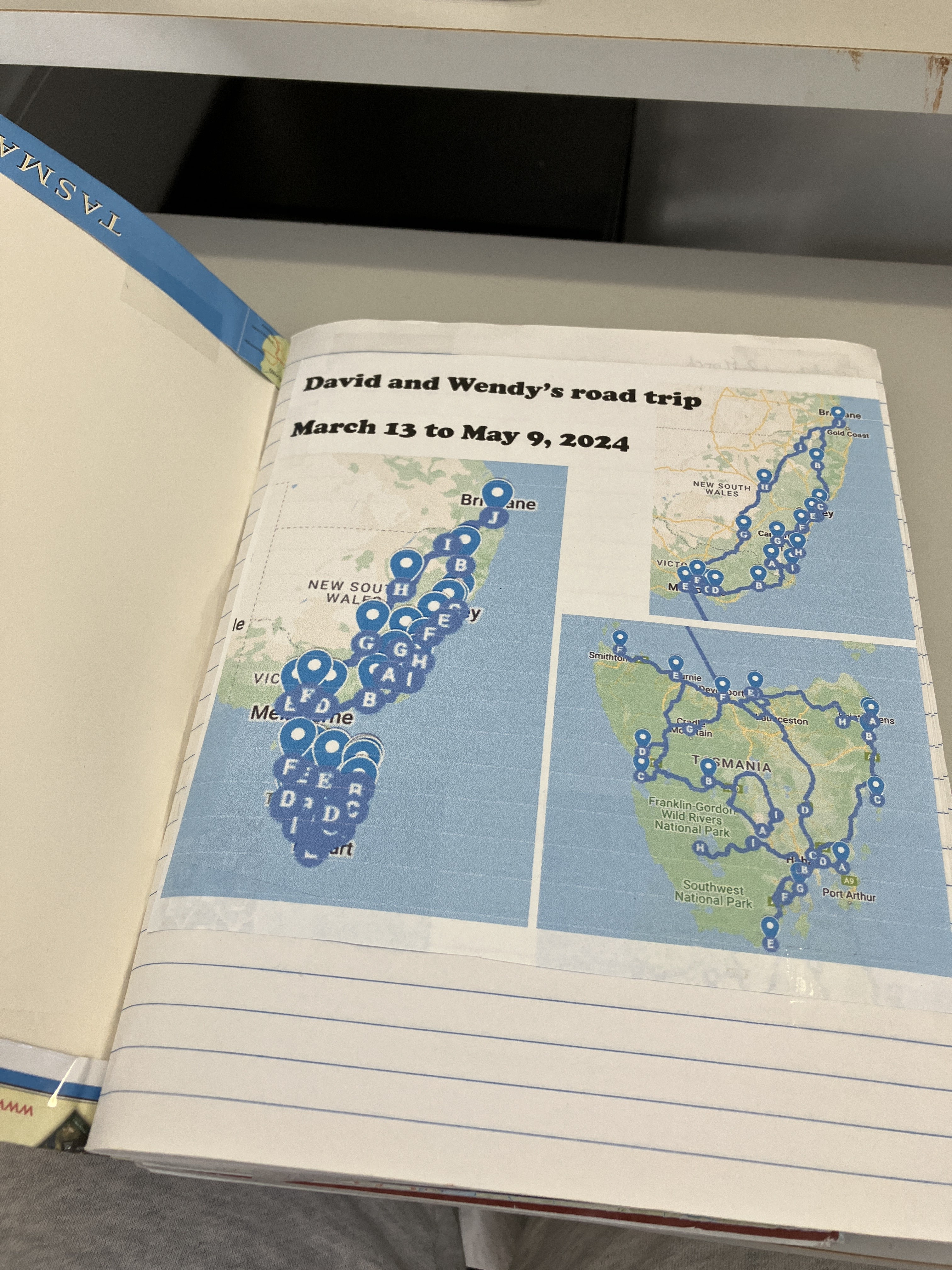
We travelled for over eights weeks. And it was a long way: 7,479 km! It's hard to find a good comparison for that. It's further than if we'd driven either the east or west coast of the US from top to bottom and back again. It's hard to give a European example, but if you start at the far west (Lisbon, Portugal) and drive east, you have still only driven just over 4,000 km when you enter Middle Eastern countries! It's also the distance as the crow flies between Brisbane, Australia and Tokyo. The larger distances were on the mainland. In Tasmania, I think our longest drive was the first day, when we drove nearly 300 km from Devonport to Lake St Claire, via the Cradle Mountain Visitor Centre.
We spent time in four states and one territory. The only ones we missed were Western Australia, South Australia, and the Northern Territory!
 |
This is a closer look at the mainland
portions of our travel. I shared a
similar image for my reflections
about the Tasmanian portion of our
journey on my Tasmanian reflections
blog post. |
We slept in 37 locations, including two separate nights on the ferry. A little more than half (19) of those were in Tasmania. We spent 8 nights out of the 58 out of the van (two nights on the ferry, three nights with family/friends, one night in a motel when I was sick, and two nights at a conference).
We're so thankful we had no breakdowns or accidents. Driving a borrowed vehicle is always concerning. We were covered by my parents insurance, but happy not to have to call upon it. The possibility of accidents is the underlying anxiety for me on long road trips. I have to work hard not to imagine worst case scenarios. It was a relief to get home again unscathed.
Climate. I wrote about Tasmania's climate in April here. But regarding our whole trip, I was amazed at how fast we could change from one zone to another. We left Queensland in shorts and t-shirts, but on the first night, six hours south of Ipswich, we found ourselves pulling out warmer gear as we camped on the Northern Tablelands of NSW.
Our favourite places to camp were the less crowded and the ones that were less well-known. I'm glad we were in Tasmania during a "shoulder" season. Even though two of the weeks we were there were school holidays, most of the places we visited weren't overly busy.
Montagu, Grants Lagoon, and Dora's Point would be among our favourites (all Tasmania) even though none of these had showers. Most caravan parks were in good shape (David's the underlying factor here, he booked the caravan parks and checked reviews before he did). It's hard to choose a favourite caravan park, though Tomakin was very good (south coast of NSW near Batemans Bay). Lake St Claire and Mount Field National Park were also good. Wagga Wagga free camp was the most crowded and most uncomfortable we felt.
The campsite on a farm near Dalgety (in the Snowy Mountains) was possibly the most quirky place, with a flushing toilet all on its own up on a hill, but without electric or showers, also, almost no trees. I think was the only place we stayed that was private property, basically a farm stay, and we had very chatty hosts, it was a pity that I felt so terrible at the time.
We managed surprisingly well with limited privacy or personal space. We're still very good friends!
I wondered how I would manage, using shared bathrooms and toilets for the whole journey because I'm a bit particular about cleanliness. It wasn't too bad most of the time, though there were times that I wished I was post-menopause (sorry if this is TMI). I can't deny it's been wonderful to be home and have our own bathroom and toilet.
 I rediscoverd my love of paper maps. We bought a road map of Tasmania for $5 on the boat on the way over and were so glad so many times that we had it (especially when there was not internet connection). I’ve practically worn that one out: it’s been folded multiple times the “wrong” way, just so we could see the little bit of Tassie we were in at the time. Some of the folds have torn now, but it was a welcome tool on the trip that we used almost every day.
I came home with an even greater appreciation of my own toilet and shower, water on tap, a laundry and kitchen, a fluffy towel, and WiFi! And smaller things like being able to leave my toothbrush out (not packed away).
A motorhome is very convenient, though. Most everything you use regularly is practically within reach all the time! Of course smaller motorhomes aren’t so convenient, for example, having to pack up the table to make a bed, or lift up the bed to get to the storage underneath it. Ours felt just the right size for the two of us. I was particularly appreciative of the always available bed, especially when I was unwell.
Here's phrase that I've pondered: "romance of the open road". What is it that makes people desire to get away in caravans and motorhomes, or to do long "road trips"? The cynical me says its running away from responsibilities, but I think I'll leave that thought aside and focus on reflections here. It is a little "weirdness" about a big country like Australia that we have this thing of loving to drive long distances. In fact it's the best way to see our large land. But it's gotten a little crazy here in Australia as our Baby Boomers have hit retirement age and many have hit the road!
David says I must include a link to a fun video by an Australian comedian about people who have done "the lap" (driven all the way around Australia in a caravan or motorhome): https://www.facebook.com/reel/292003200631967 (I can't find a Youtube link). I don't think we are this inarticulate about our journey, so please don't hesitate to ask :D. We've got a few good stories.
Sickness while travelling isn’t fun. It was quite difficult and distressing, actually. I'm thankful we didn’t end up having to make major changes to our journey, though that was on the cards and caused some of my anxiety and stress. It was difficult to get a diagnosis and treatment amidst the travel and public holidays and I was surprised that areas I didn't think were remote, were actually, at least in a medical sense. I still have some lingering discomfort, which concerns me, but hopefully that will go away with time (tests done last week don't show any cause for this discomfort). I'm thankful for the online medical services that have popped up in the last few years that made getting access to medical help a bit easier (but not as good as being at home with your own GP who could assess you and follow up).*
WiFi matters. If you're going to write a travel blog it matters more. So does taking time to write along the journey. I sometimes got that right, but was often foiled by a lack of WiFi, and even at one location, by a lack of any kind of internet at all (our phones said "SOS only" in the place that usually tells you how many bars you have).
 |
| My travel diary/scrapbook |
 Travelling is tiring (which I really knew…) and time consuming. We took quite a few non-electronic things to keep us occupied as we could hardly imagine two months of holidays. We enjoyed puzzle magazines and Scrabble. Some of the other small games too, that we took. I started a new hobby, Wool Felting, but struggled without the internet to guide me on the intro video. I also took my “big” camera, but hardly used it, it was easier just to pull our my phone. We didn’t touch the colouring books we took. Of course blogging took up a lot of time and the other project I did was a scrapbook journal. Not to mention books (I read more than a dozen, plus we listened to three audiobooks while driving). These were all good ideas and we never were bored. But we had less free time than what I’d feared (and yes, I hate being bored). Being sick for a couple of weeks decreased my energy levels for extra curricular activities. And the cold meant we often went to bed early and got up latish: bed was the warmest place and it was easy to read there.
One of the big things we learned was about being more spontaneous and adaptable. Parenting with our particular family dynamics (see here for more on that) has meant we've spent many years learning to plan ahead. We're pretty good at it now, but what we're not good at is spontaneity. After practicing something for over 20 years you don't unlearn it quickly! ....
A friend following our journey has surmised that I like travelling, but I think I like the idea more than the reality. I'm a bit of a home girl deep down. However this trip had so many fun things about it (and not too much staying in other people's homes) that it was hard not to enjoy much of it, even if I was longing at times for home. In reality we've been in transition since early last year, I'm a bit tired of it all. I know we're going to have to pack up and leave our current place in under two months and I'm longing to get to a more permanent "home" in Tokyo and stop there (I hope) for longer than a year (at least have that as our home base for longer, that's not to say that we won't travel).
But I'm so thankful for this break. It's been great to get away from all the usual demands and to just concentrate on travelling and seeing parts of our amazing home country. I think I especially appreciated being anonymous: not having to talk about Japan, or our family, or why we were doing what we were doing (which happens in both Australia and Japan). Some people we talked to last year were concerned about us—that we hadn't had a good holiday for a while, and indeed we barely took any in 2023 at all (at least a go-away-to-relax holiday). This has made up for that, I think. We have so many good memories and are ready to move on to the next thing, mentally at least, I think.
* For Aussies who read this, there are a variety of online medical services available these days to see a GP (probably in part due to COVID-19). I was surprised, but also a little naive. One, Doctors on Demand, was quite expensive. Another is 13SICK and is only open on public holidays and after hours. Literally, they open at 5 pm and shut at 8 am. That was "bulk billed" but even after contacting them literally at 5 pm to get in their virtual line, I waited hours for them to call me back. And if they order a test, they won't talk to you about the results, you have to go to your "ordinary" doctor.


